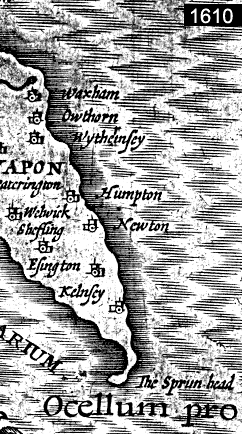
There have been several lighthouses on Spurn over the centuaries. The first is recorded around 1427, the last closed down in 1986. The peninsula has belonged to the Yorkshire Wildlife Trust since 1950. Each successive spit has grown until it has become unstable, been destroyed by the sea and then rebuilt itself slightly to the west of the former one, almost every 250 years. The animation shows some historical maps and the schematic evolution of spurnpoint.
"The main processes involved in the building of Spurn seems fairly clear. Material derived from the erosion ot the coast of Holderness is moved by wave action along the beach to the tip where some is swept by the ebb tide on to the Binks, some is carried to the wide sand flats inside the tip, and the rest contributes to the still continuing growth of Spurn southwards." 5
Über die Jahrhunderte hinweg gab es viele Leuchttürme auf der Halbinsel. Der erste wurde 1427 gebaut, der letzte wurde 1986 außer Betrieb genommen. Seit 1950 ist die Insel Teil eines Naturschutzreservates. Ca. Alle 250 Jahre wird die Spitze instabil, vom Meer zerstört und entsteht wieder neu weiter im Westen. Die Animation zeigt historische Landkarten und die schematische Entwicklung der Halbinsel.
"Die Hauptursache, die für die Entstehung von Spurn verantwortlich ist, scheint klar zu sein. Material, dass von der Erosion der Holdernessküste stammt wird durch die Wellentätigkeit am Strand entlang zur Spitze bewegt. Ein Teil des Materials wird bei Ebbe auf den "Binks" abgelagert, ein Teil wird zu den weiten Sandflächen auf der Innenseite der Spitze getragen und der Rest dient dem beständigen Wachstum von Spurn südwärts. " 5